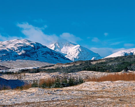
With elegant lines and an alpine-like grace, Ben Lui is one of the most beautiful mountains in Scotland.
It’s the tallest peak in a line of four – Beinn a’ Chleibh, Ben Lui, Ben Oss and Beinn Dubhchraig – that zig-zags east to west between Tyndrum and Crianlarich. Although its neighbours are also Munros, they’re far smaller and Ben Lui, appears to stand alone – a proud pyramid.
The hill looks its best when approached from the north-east, from where its most distinctive feature, the great bowl of Coire Gaothaich, is clearly visible.
This corrie usually holds snow late into summer, when all around is a green, lending the mountain even more of an alpine aspect. Easy access by railway meant Ben Lui was a hill popular with Scotland’s mountaineering pioneers in the Victorian era.
Coire Gaothaich holds a number of lower-grade winter routes for climbers. Most famous is Central Gully, first climbed in 1892. #
It is a Grade 1 but in a thrilling situation and feels much more adventurous. It pops you right out on the summit.
The quickest way up the hill is from the north-west, the Glen Lochay side. There’s a car park off the south side of the A85. It involves an awkward river crossing and there’s the railway to negotiate. You’re required to go beneath it – crossing the rails risks your life and a hefty trespass fine.
The underpass also contains a stream, so you’re likely to get your feet wet. After that, it’s a steep slog up grassy slopes.
Hardly an inspiring route for such a majestic hill. Taking in the adjacent Beinn a’ Chleibh gives a route of about 10km (6.2 miles), with 1,100m (3,609ft) of ascent and will take four or five hours. Far better for those who like a bit of scrambling is the longer route from Dalrigh via Cononish.
Much of the way can be cycled, saving a lot of time.
Pronunciation: Ben Loo-ay
Meaning: Hill of the calf
Height: 1,130m (3,707ft)
OS Landranger Map: 50
Summit grid ref: NN266263
Nearest town: Tyndrum lies just 7.5km (4.7miles) north-east. The small settlement at the junction of the A82 and A85 has two train stations, a pub, hotel, caravan and camping site and the famous Green Welly Stop, which sells everything from petrol to outdoor gear.
For award-wining fish and chips, visit the Real Food Cafe.
Start grid ref: NN343291
Distance: 18.5km (11.5 miles)
Ascent: 1150m (3773ft)
Time: 7hrs
Parking area at Dalrigh. Road leads west, following north bank of River Cononish. About 1.5km (0.9 miles) before farm at Cononish, another road merges from the north. The glen beyond the farm is the site of the gold-mine workings.
Not the prettiest of sections but the north-east face of Ben Lui will draw the eye. Track ends at the Allt an Rund.
A path leads up into Coire Gaothaich. At a more level section, strike north-west up much steeper ground, aiming for Ben Lui’s north-east ridge.
On the ridge, the route becomes steep and narrow, a wonderful way up a beautiful hill. The scrambling is simple and ends quite suddenly at the Munro’s north-west top.
A short traverse over easy ground takes you to summit. Although relatively undemanding in summer conditions, this can be a testing route in winter.
There’s gold in them thar hills
A controversial gold mine at Cononish, at the foot of Ben Lui, was granted full planning permission in February, 2018.
It’s the first commercial gold mine in Scotland, and was given the green light after a site visit by Loch Lomond and The Trossachs National Park planning committee.
Mountaineering Scotland objected to the proposals, but the Strathfillan community group was supportive.
Operators Scotgold Resources aim to mine more than 500,000 tonnes of ore over a 17-year period.
The company plans to invest £500,000 in the local community and says up to 52 jobs could be created.
A temporary bridge will be built to keep mine traffic away from walkers on the West Highland Way long-distance route from Milngavie to Fort William. An earlier trial saw the mine produce gold for the first time in August, 2016.

Enjoy the convenience of having The Sunday Post delivered as a digital ePaper straight to your smartphone, tablet or computer.
Subscribe for only £5.49 a month and enjoy all the benefits of the printed paper as a digital replica.
Subscribe