Studying the route of five Munros in Glen Etive on our map, I could see it would be a big day out.
With a sea-level start, a total ascent of 8,400ft and a walk of 15.5 miles, it would be tough.
Even my husband Gordon – who usually mutters about it being “a bit of a cinch” – said: “It’s going to be challenging, with lots and lots of up and downs.”
He had previously hiked the five mountains in the Glencoe area of the Highlands as two one-day outings, although many people are likely to split the five peaks into three or four trips.
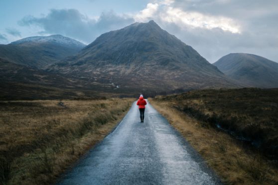
After a night in Fern the campervan, we set off at the north-east end of Loch Etive. Almost immediately, we had a stiff climb. The mountain of Ben Starav loomed ahead, a magnificent yet ominous bulk of rock that would take us to the highest point of the route.
The angle of the narrow, rocky path didn’t allow for a warm-up – at about 1,900ft there was a slight easing, though it was bouldery.
Thinking of the many miles ahead, we rarely stopped to catch our breath, yet when we did we were rewarded with superb views back along Glen Etive.
Until we reached about 2,600ft elevation, the sun shone in a bright-blue sky and we thought the weather forecast was somehow wildly wrong. Of course, it wasn’t.
Making a final climb to the 3,537ft summit along an undulating ridge of rocks, we were suddenly surrounded by thick clouds. Sadly, there was no view from the top and, for the next few hours, the clouds came and went.
The next summit, Beinn nan Aighenan, is a relatively remote peak and many people bag it on its own. Instead, we detoured from the ridge, south for a distance of 2.5 miles, to the 3,150ft peak.
This section required a descent to a low point of 1,900ft before climbing again. We enjoyed several cloud-free views and were able to drop our rucksacks at the bealach because we would be retracing our steps.
Thick mist again surrounded us as we ascended and, out of nowhere, three men approached us.
They told us they planned to walk four of the five Munros and had, perhaps sensibly in retrospect, missed out Starav.
A small cairn marked the top and we didn’t wait around because it was wet and cold.
Back at the bealach, the clouds made visibility tricky and for several tense minutes we struggled to find our packs. Thankfully, their bright colours jumped out in a patch of faded mist – and we carried on to Munro number three.
Glas Bheinn Mhor seemed easier after the first two mountains – at first, we mistook a waymarker cairn for the top.
It was only when we checked our watches for an altitude reading that we knew we weren’t there – 20 minutes more took us to the summit at 3,271ft.
At this stage, we knew it was important to take the right bearing to reach Munro four. We spent time looking at the map and working out the best line.
We considered, too, the option to cut the long walk short, returning to Glen Etive and leaving Stob Coir’an Albannaich and Meall nan Eun for another day. But Gordon and I relish a challenge, so we kept going.
Through a gap in the clouds, we could see the hulk of Stob Coir’an Albannaich. The corries north and south can be tricky to navigate so we frequently reassessed our bearing. Rising to 3,425ft, it was a beast of a hill and the climb went on forever. At the summit, I thought: “Just one more, then we can get back to the campervan”.
This meant that as we plodded on towards Meall nan Eun my spirits were high.
My leg muscles were becoming fatigued and the usual niggles of sore hips and knees were starting to plague me.
Resting at the top of Munro five, I asked Gordon how long it would take to walk back to the van. When he said about two-and-a-half hours, I could hardly believe him.
We had been on challenging terrain for almost eight hours and I had been hoping it would be a short stroll along the glen to return. I had been fooling myself!
The descent from Meall nan Eun summit at 3,045ft to Coire Riabhach was steep and craggy.
Further on, while a gentler gradient, the ground was rough, tussocky and boggy. We followed a muddy path alongside the rushing waters of Allt Ceitlin.
Finally, the clouds lifted and we could delight at great views.
Eventually – and I emphasise that word – we reached a track in Glen Etive. I was so sure this must be where we had left the van but, no, we had further to go.
It felt like we had slowed to half our usual speed and, even when we finally saw the blue van ahead, we had no energy left to pick up our pace.
There are many advantages of campervan ownership, but the one I was most thankful for at the end of this big hike was a meal ready to be heated on the stove.

Enjoy the convenience of having The Sunday Post delivered as a digital ePaper straight to your smartphone, tablet or computer.
Subscribe for only £5.49 a month and enjoy all the benefits of the printed paper as a digital replica.
Subscribe