Storm Kathleen is expected to bring both strong winds and the hottest day of the year so far for the UK, as it pummels the country with warm air from the continent this weekend.
The Met Office said temperatures could reach up to 22C in East Anglia, while western areas will see gusts of up to 70mph on Saturday.
The forecaster has issued a yellow weather warning for wind in the north west and south west of England, parts of Northern Ireland, Scotland and Wales, from 8am to 10pm on Saturday.
⚠️ The weekend is fast approaching and so too is #StormKathleen
🌤️ But despite the strong winds, there'll also be some warm sunshine at times on #Saturday
Find out when you'll have the driest conditions by checking the #4cast 👇 pic.twitter.com/xMgYGDQH8E
— Met Office (@metoffice) April 5, 2024
Met Office meteorologist Ellie Glaisyer told the PA news agency: “The storm is the reason we are seeing the warmer temperatures, because the location of the storm – situated out towards the west of the UK – is bringing a southerly wind across the UK.
“This is bringing those warmer temperatures from the continent, meaning we are likely to see temperatures reaching 22C.”
The highest temperature of the year so far was 19.9C, recorded at the end of January at Achfary in north-west Scotland.
“Storm Kathleen is likely to bring some heavy rain across the UK overnight, which will spread its way northwards across the country,” Ms Glaisyer said, adding: “For most places it should be a relatively dry start to Saturday.”
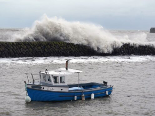
Storm Kathleen is also expected to bring 50-60mph winds quite widely on Saturday, while some Irish Sea coastal regions will see gusts up to 70mph and large waves.
Ms Glaisyer said: “Almost anywhere is going to see above average temperatures. Western parts of the UK are likely to see temperatures of 15 or 16C.
“However, the further west you are, where those strongest winds are in that yellow warning area, despite the temperatures being above average it will feel a little colder.”
On Friday, the Met Office updated its weather warning to forecast stronger gusts during Storm Kathleen than previously predicted.
It warned of injuries and danger to life from “large waves and beach material being thrown onto sea fronts, coastal roads and properties”, a possibility that “road, rail, air and ferry services may be affected” and the potential for power cuts and phone service outages.
The forecaster said winds would stay strong into Sunday, particularly in northern parts of Scotland.
“There will still be some showers around, but there should be some sunshine between those showers”, Ms Glaisyer said, adding: “It is generally remaining unsettled through much of next week.
“There is another area of low pressure moving towards the UK through Monday and into Tuesday. That is likely to bring some heavy rain for much of the UK, particularly in the West.
Storm Kathleen, named by the Irish meteorological service Met Eireann, is the 11th named storm in eight months.
#StormKathleen has been named by @MetEireann and is forecast to bring strong winds to Ireland and much of the UK on Saturday
Stay #weatheraware pic.twitter.com/dcDmifdqjL
— Met Office (@metoffice) April 4, 2024
It is only the second time in a UK storm season that the letter K has been reached in the alphabet.
The Met Office’s shipping forecast had 20 gale warnings in place on Friday evening for sea areas including Viking, Plymouth, Biscay, Sole and Lundy.
The Environment Agency (EA) issued 14 flood warnings – where flooding is “expected” – and 123 flood alerts in England on Friday, with National Resources Wales issuing four flood alerts.
The Environment Agency also issued 43 red cautions for strong streams on the River Thames, advising users of all boats not to navigate.
RAC Breakdown spokesman Rod Dennis said: “This intense period of stormy weather is going to prove extremely challenging for anyone driving on the western side of the UK.
“We strongly urge drivers to avoid exposed coasts and higher routes where the impact of the very strong winds is most likely to be felt.”

Enjoy the convenience of having The Sunday Post delivered as a digital ePaper straight to your smartphone, tablet or computer.
Subscribe for only £5.49 a month and enjoy all the benefits of the printed paper as a digital replica.
Subscribe