Calendar An icon of a desk calendar. Cancel An icon of a circle with a diagonal line across. Caret An icon of a block arrow pointing to the right. Email An icon of a paper envelope. Facebook An icon of the Facebook "f" mark. Google An icon of the Google "G" mark. Linked In An icon of the Linked In "in" mark. Logout An icon representing logout. Profile An icon that resembles human head and shoulders. Telephone An icon of a traditional telephone receiver. Tick An icon of a tick mark. Is Public An icon of a human eye and eyelashes. Is Not Public An icon of a human eye and eyelashes with a diagonal line through it. Pause Icon A two-lined pause icon for stopping interactions. Quote Mark A opening quote mark. Quote Mark A closing quote mark. Arrow An icon of an arrow. Folder An icon of a paper folder. Breaking An icon of an exclamation mark on a circular background. Camera An icon of a digital camera. Caret An icon of a caret arrow. Clock An icon of a clock face. Close An icon of the an X shape. Close Icon An icon used to represent where to interact to collapse or dismiss a component Comment An icon of a speech bubble. Comments An icon of a speech bubble, denoting user comments. Comments An icon of a speech bubble, denoting user comments. Ellipsis An icon of 3 horizontal dots. Envelope An icon of a paper envelope. Facebook An icon of a facebook f logo. Camera An icon of a digital camera. Home An icon of a house. Instagram An icon of the Instagram logo. LinkedIn An icon of the LinkedIn logo. Magnifying Glass An icon of a magnifying glass. Search Icon A magnifying glass icon that is used to represent the function of searching. Menu An icon of 3 horizontal lines. Hamburger Menu Icon An icon used to represent a collapsed menu. Next An icon of an arrow pointing to the right. Notice An explanation mark centred inside a circle. Previous An icon of an arrow pointing to the left. Rating An icon of a star. Tag An icon of a tag. Twitter An icon of the Twitter logo. Video Camera An icon of a video camera shape. Speech Bubble Icon A icon displaying a speech bubble WhatsApp An icon of the WhatsApp logo. Information An icon of an information logo. Plus A mathematical 'plus' symbol. Duration An icon indicating Time. Success Tick An icon of a green tick. Success Tick Timeout An icon of a greyed out success tick. Loading Spinner An icon of a loading spinner. Facebook Messenger An icon of the facebook messenger app logo. Facebook An icon of a facebook f logo. Facebook Messenger An icon of the Twitter app logo. LinkedIn An icon of the LinkedIn logo. WhatsApp Messenger An icon of the Whatsapp messenger app logo. Email An icon of an mail envelope. Copy link A decentered black square over a white square.

Snow, sleet and gale force winds to hit east of Scotland

Post Thumbnail

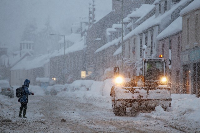
SNOW and sleet are expected to hit parts of the UK from tomorrow night as temperatures plummet and gale-force winds sweep in from the Arctic.

Weather forecasters have said the milder-than-normal temperatures of the last weeks will drop to below freezing in some areas, bringing snow to eastern areas of Scotland and the North Pennines by Friday evening.

High hills in England and Wales can also expect some snow to accumulate as two cold fronts sweep in from the Arctic over the day and head south. Most other areas can expect wintry showers and some sleet.

Paul Mott, forecaster at MeteoGroup, said: “Friday won’t be too bad a day and there will be sunny spells, but it will be chilly and breezy with showers that will turn to snow in some areas in Scotland in the evening.

“Another cold front on Friday night will bring outbreaks of snow and sleet across the UK, but the hills of Wales, Scotland and England will have the most accumulations.

“Saturday will also be cold but we will see an improving picture, but temperatures will stay around a maximum of 3C-4C (37.40F-39.2F) in most areas.

“It should continue to pick up a bit, but we may see some frost on Sunday and into Monday morning.”To read more about the winter weather, click here While the worst of Storm Barney may have passed, fresh gale-force winds will batter mostly northern areas again throughout the weekend, according to the Met Office.

A moderate weather warning has been issued for Northumberland where winds of up to 63mph are expected. According to the Beaufort Scale, this could typically result in uprooted trees and structural damage to buildings.

Similar warnings are also in place for County Durham and Newcastle upon Tyne over Friday and Saturday, where winds are expected to reach 47mph and 48mph respectively.

The Met Office has said this weekend will feel “noticeably colder” across all regions, with a lot of areas waking up to a “raw” Saturday morning.