FORECASTERS have warned that gusts of up to 90mph could hit the country with the arrival of Storm Caroline, causing potential danger to life.
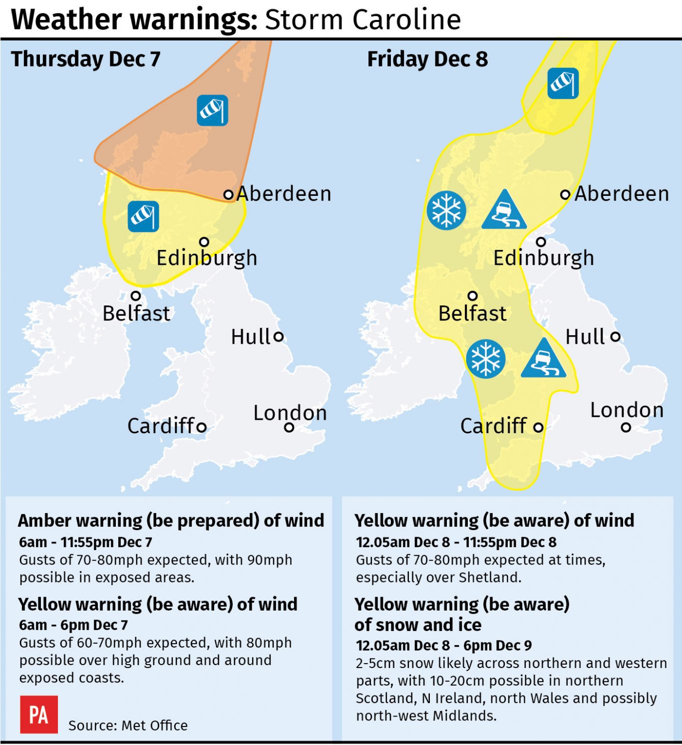
The Met Office has raised the level of its weather warning from yellow to amber “be prepared” for northern Scotland on Thursday, warning of very windy weather.
Transport is likely to be disrupted while there may also be power cuts.
The strong wind warning is valid from 6am until 11.55pm on Thursday, with an amber warning for northern Scotland.
A yellow “be aware” warning is in force for the southern half of Scotland and parts of the north of Northern Ireland between 6am and 6pm on December 7.
The Met Office said gusts of 70mph to 80mph are expected widely in northern Scotland, with gusts of up to 90mph possible in exposed areas.
It said: “Flying debris is likely and could lead to injuries or danger to life. Some damage to buildings is possible, such as tiles blowing off roofs.
“Longer journey times and cancellations are likely as road, rail, air and ferry services may be affected. There is a good chance that power cuts may also occur.
“Large waves are expected and beach material may be thrown onto coastal roads, sea fronts and properties.”
#StormCaroline will bring a spell heavy rain and damaging winds with the greatest impacts likely for Scotland and the far north of Northern Ireland on Thursday #weatheraware pic.twitter.com/6hAYRYVcU8
— Met Office (@metoffice) December 6, 2017
The yellow warning for the southern half of Scotland and Northern Ireland says gusts of 60mph to 70mph are expected quite widely, with gusts of up to 80mph possible over high ground and around exposed coasts.
It warns of possible disruption to travel and some short-term loss of power and other services.
Coastal routes, seafronts and coastal communities are likely to be affected by spray or large waves.
Conditions will start to turn wet and blustery on Wednesday, especially across the north and north west of the UK, before the gales hit on Thursday.
Met Office meteorologist Marco Petagna said: “Wednesday will see the last of the mild days, with temperatures in double figures, between 10C and 12C (50F-54F).
“Overnight, the main feature will be the increase in wind as Caroline starts to come in towards the end of the night.”
Meanwhile, dozens of workers are being removed from a North Sea platform due to safety fears over weather conditions caused by Storm Caroline.
CNR International said a total of 69 of the 159 staff on Ninian South, about 240 miles from Aberdeen, would be leaving the structure as a precaution.
Snow and falling temperatures are also forecast for parts of Britain later in the week.
A yellow snow and ice warning is in place for Friday for Scotland, Northern Ireland, western England and Wales.

Enjoy the convenience of having The Sunday Post delivered as a digital ePaper straight to your smartphone, tablet or computer.
Subscribe for only £5.49 a month and enjoy all the benefits of the printed paper as a digital replica.
Subscribe