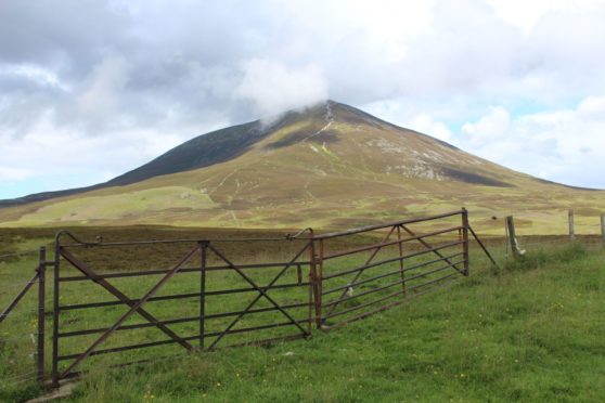
When Carn Liath looms into view shortly after passing Pitlochry while heading north on the A9, it feels like you’re about to enter the “real” Highlands.
Carn Liath is one of the three Munros that make up Beinn a’ Ghlò – which is more mini-mountain range than mountain. The other Munros are Braigh Coire Chruinn-bhalgain and Carn nan Gabhar.
Immediately north is beautiful Glen Tilt, and beyond there the remote hills around Tarf Water. South is Ben Vrackie, the Corbett above Pitlochry, the summit of which offers fine views of Beinn a’ Ghlò. Although Carn Liath is the smallest of the three Munros, for many – being so visible from the A9 – it’s the “face” of Beinn a’ Ghlò.
The higher peaks are hidden further north and west from this angle. It’s also the easiest to access and the quickest to climb – a brief up-and-down from the road end at Loch Moraig.
But it’s not the best way to enjoy the hill. Far better is the traverse of all three Munros – it’s a big day but another of Scotland’s hillwalking “classics”. Pick your weather day and it’s sure to live long in the memory – Beinn a’ Ghlò is widely considered the best of the southern Cairngorm hills along with Lochnagar.
Sadly, one of Carn Liath’s features is the wide, eroded scar of a footpath that mars its south-western slope. It’s the result of many thousands of boots treading the slopes and is visible from a considerable distance.
Fundraising is under way to repair this damage and construct a new route. The British Mountaineering Council – working with Mountaineering Scotland and the Outdoor Access Trust for Scotland – is seeking to raise £1 million in a campaign called Mend Our Mountains. In Scotland, Carn Liath in the Cairngorms National Park, Ben Vane, in Loch Lomond and The Trossachs National Park will be worked on.
How glen forced a legal sea change
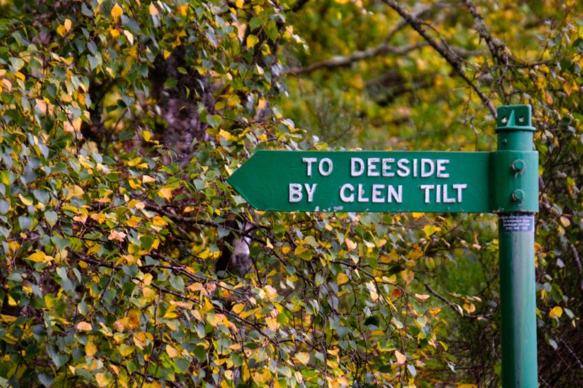
Nearby Glen Tilt played an important role in establishing the public right of access to Scotland’s countryside.
On August 21, 1847, Edinburgh University botany professor James Balfour led a party of students through Glen Tilt en route to Blair Atholl. The group, on a field trip, left Braemar that morning, travelling by carriage to upper Glen Tilt.
Balfour was certain the route was a right of way but, as they neared the foot of the glen, they found their way barred by the Duke of Atholl’s ghillies. A three-hour stand-off ensued, with the Duke himself arriving to remonstrate with the party. He insisted they return to Braemar – hardly a realistic request. Eventually the professor and students leapt a dyke and made for Blair Atholl, pursued all the way by the Duke’s men.
The so-called “Battle of Glen Tilt” led to a lengthy court battle that eventually saw the right of way through the glen recognised in law.
Guide
Pronunciation: Carn Lee-ah
Meaning: grey cairn
Height: 975m (3,199ft); Rank: 181
OS Landranger Map 43
Summit grid ref: NN936698 (cairn)
Nearest town: The village Blair Atholl is about 8km (5 miles) south-west. It has accommodation, a campsite, garage and selection of shops and places to eat. The spectacular Blair Castle is home to the UK’s only private army, the Atholl Highlanders.
The route
Start grid ref: NN905670
Distance: 21km (13.1 miles)
Ascent: 1,350m (4,429ft)
Time: 9hrs
As well as Carn Liath, my route takes in the two other Beinn a’ Ghlò Munros – Braigh Coire Chruinn-bhalgain and Carn nan Gabhar. The usual route up Beinn a’ Ghlò starts near Loch Moraig, from the car park/layby at the end of the narrow Monzie road out of Blair Atholl. A track leads to Carn Liath, and the eroded path up the slopes leaves no doubt as to the route.
With much of the day’s ascent quickly out the way, what lies ahead is a fantastic, high-level walk. A twisting broad ridge leads to the next Munro, at 1,070m (3,510ft). From here, in poor visibility, the next section from the cairn to the bealach can be tricky. North-west from the second, lower summit, is a steep descent route east to the Bealac h an Fhiodha.
Its start is a couple of hundred metres south of Pt 993m. From the bealach, a path takes a rising traverse to the ridge leading to Carn nan Gabhar. The ground is stony and the summit is not the trig point, but the large cairn some distance beyond. At 1,121m (3,678ft) it’s the highest peak of the day.
Descending south-west takes you over Airgiod Bheinn. Traversing rough moorland south-east takes you to the access track and what will feel like a long the walk back to the start.

Enjoy the convenience of having The Sunday Post delivered as a digital ePaper straight to your smartphone, tablet or computer.
Subscribe for only £5.49 a month and enjoy all the benefits of the printed paper as a digital replica.
Subscribe