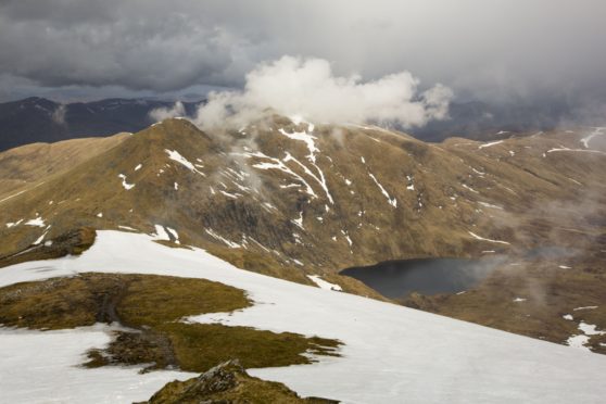
Just north of the picturesque Stirlingshire tourist town of Killin lies Meall nan Tarmachan.
It’s the highest peak – and only Munro – of a snaking, sinuous group of hills that makes up the Tarmachan Ridge, famously the narrowest mountain ridge in what was once Perthshire.
Meall nan Tarmachan can be climbed as a simple there-and-back in a few hours from the Ben Lawers car park – but to miss out the ridge is to forego one of the best hillwalks in central Scotland.
It’s a spectacular day out. The other peaks on the Tarmachan Ridge are Meall Garbh, Beinn nan Eachan and Creag na Caillich. The best view of the hills is from Killin. They rise in a steep wall above the town, the gnarled rocky ridge making for an impressive skyline.
The route to the Munro follows a decent path and is relatively simple – despite measuring 3,425ft, the high start from the car park at about 1,476ft makes Meall nan Tarmachan one of the easiest Munros.
That said, it took me a few attempts to climb it – including one in which I couldn’t even make it to the car park, as the untreated, single-track road was buried in deep drifts. And the first time I actually summited the Munro, severe winds, blizzards and a complete lack of visibility meant just retracing the route to the car felt like an achievement.
Attempting the ridge would have been plain daft. In good conditions, the ridge is an exciting jaunt. It’s also relatively short – making it a viable, if challenging, winter day out.
In summer, the clear path makes the route choice obvious. The way is narrow in places – with some big drops and crags – but the scrambling is never difficult. The hardest section is Grade 1 and is easily avoidable on a bypass path.
History in the hills… ancient Scots axe men
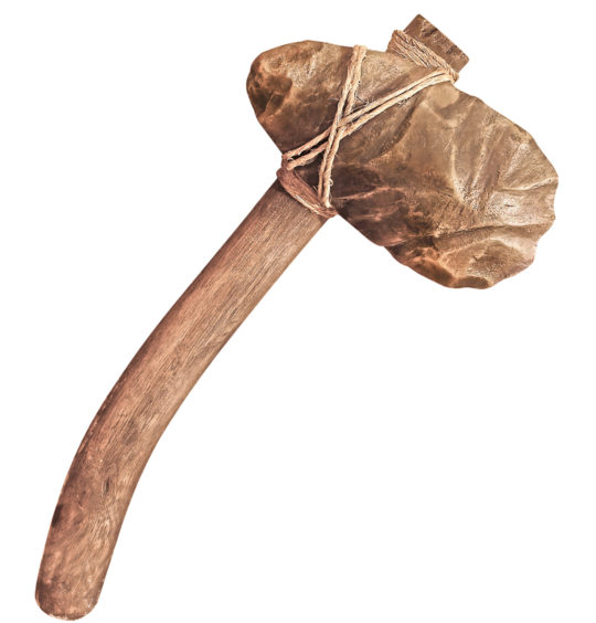 © Shutterstock / prapann
The area around Meall nan Tarmachan has an amazingly rich history, with evidence of human occupation going back many thousands of years.
Some 1,968ft up on Creag na Caillich, the most westerly of the Tarmachan Ridge’s peaks, is the site of an ancient stone-axe production site. It’s very rare – one of just a handful in the UK. The earliest evidence of quarrying for stone to make the axe-heads dates to almost 3,000 BC. It was the time of the Neolithic in Scotland – the “New Stone Age”.
On the Edramucky Burn, on the slopes of nearby Ben Lawers, evidence of even earlier activity has been discovered. Archaeologists have uncovered the site of a temporary campsite used by hunter-gatherers in the Mesolithic era – the “Middle Stone Age”. Radiocarbon dating of burnt remains dates the site to an incredible 9,000 years ago.
Guide
Pronunciation: Me-yal nun Tar-machan;
Meaning: hill of the ptarmigan
Height: 3,425ft; Rank: 89
OS Landranger Map 51
Summit grid ref: NN585390 (cairn)
Nearest town: Killin lies 4.4 miles south-west. There are plenty of places to eat and drink, a variety of shops, including an outdoor store and supermarket and holiday parks and hotels. The Falls of Dochart Inn – an 18th-Century blacksmith’s forge – is a great spot for a pint.
The route
Start grid ref: NN608377
Distance: 8.1 miles
Ascent: 2,461ft
Time: 5hrs
A superb path leads from the track out of the Ben Lawers NTS car park (charge).
It leads to another vehicle track – walk straight across this. Continue on the path up grassy slopes all the way to Meall nan Tarmachan’s south-east top at 3,028ft. The path then descends very slightly and leads over a flatter section before climbing through crags to the summit. The views over to Ben Lawers are fine – but the best of the day awaits.
First head south, then south-west to a bealach with two lochans – it’s then a steep, brief climb up rocky ground to the summit of Meall Garbh. The path leads to a wonderful grassy arête. After the arête is a rocky descent – a Grade 1 scramble and the trickiest part of the route. There is a bypass path. Next top is Beinn nan Eachan – again a clear path leads to the next bealach.
It’s worthwhile climbing the final top – Creag na Caillich. Easiest descent is to return to the bealach, before picking your way down steep, grassy slopes into the Coire Fionn Lairige. On reaching a disused quarry, turn left along the old access road. It’s roughly 2.5 miles back to the start point.

Enjoy the convenience of having The Sunday Post delivered as a digital ePaper straight to your smartphone, tablet or computer.
Subscribe for only £5.49 a month and enjoy all the benefits of the printed paper as a digital replica.
Subscribe