Few hills in the Central Highlands feel as remote as Stuchd an Lochain.
The hill rises above Loch an Daimh, deep along Glen Lyon. It’s hidden up an offshoot of the minor road that runs the length of the glen to Loch Lyon.
Vehicle access to the glen from the east is from Fortingall. From the south, the Ben Lawers road that runs from the north shore of Loch Tay takes you eventually to Bridge of Balgie, where it meets the Glen Lyon road. Both routes are along twisting, narrow single track that take an age to negotiate – far longer than the distance would at first suggest.
It’s ironic then, given the effort to get there, that Stuchd an Lochain presents one of the quickest ascents of any Munro. The Giorra Dam, at which you park, lies at 410m (1,345ft) above sea level – so almost half the hard work is already done.
Even in winter – assuming you’re first able to get to the hill along untreated roads – an ascent shouldn’t take much longer than 3.5 hours. As a result, many baggers include an ascent of Meall Buidhe, which lies on the north side of the loch and is also accessed from the dam. The two together make a hill day, more or less.
Stuchd an Lochain – like any Munro – shouldn’t be underestimated though, especially in winter conditions. The initial slopes are pretty steep, and there’s another very steep section to climb to Pt 888 on Creag an Fheadain.
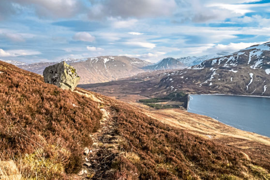
The best feature of the Munro is the beautiful little Lochan nan Cat that nestles in its northern corrie and gives the hill its name. The summit perches airily on crags directly above the lochan.
My own favourite view of the hill is from quite a distance away – from the A82 on Rannoch Moor. As you head south on the road and the Munros of Beinn an Dothaidh, Beinn Achaladair and Beinn a’ Chreachain loom into view, just to their left is Stuchd an Lochain, a graceful, low-angled and perfectly symmetrical pyramid.
Guide
Pronunciation: Stooch-k an Lochan
Meaning: peak of the little loch
Height: 960m (3150ft); Rank: 197
OS Landranger Map 51
Summit grid ref: NN483448 (cairn)
Nearest town: Killin’s the closest “big” town. It lies about 15km (9.3 miles) south-east. It has a variety of places to eat and drink, shops – including an outdoor store and supermarket – plus accommodation from holiday parks to hotels.
The route
Start grid ref: NN511463
Distance: 9km (5.6 miles)
Ascent: 715m (2346ft)
Time: 3.5hrs
From the Giorra Dam, head south on the track that curves along the shore of the loch. After about 150–200m you’ll find a rough path on the left. A cairn marks the spot but the path itself is very obvious.
It contours the hillside initially, before then swinging almost directly uphill. It’s very steep in sections, badly eroded and quite mucky in wetter weather. The ridge is gained at cairn, from where a line of old fence posts leads across a very short, easier – and drier – section, before the steep pull on to Creag an Fheadain. Head south-west from here, over a slight dip, before a sharp wee climb to Sron a’ Chona Choirein.
Head west, around the rim of the corrie. A brief climb takes you to the summit, with its cairn sitting grandly above steep crags. On a clear day, Ben Nevis is clearly visible beyond Rannoch Moor. The easiest descent is to retrace your steps – perhaps ascending Meall Buidhe from the dam if you’ve time. An even more pleasing route is to continue west over the 837m (2746ft) Corbett Sron a’ Choire Chnapanich.
Continue the circuit of Loch an Daimh over Meall Cruinn and the Munro Meall Buidhe, 932m (3058ft). The entire circuit is about 20km (12.4 miles) with 1000m (3281ft) of ascent.
The dark history of Scotland’s hill bagging hobby
Stuchd an Lochain has a claim to have the first recorded Munro ascent in Scotland – 300 years before the concept of Munros was devised!
Author Ronald Turnbull, in his book Walking Highland Perthshire, tells of how, in 1590, local laird Mad Colin Campbell of Meggernie climbed the hill with his faithful ghillie.
However Mad Colin, or Cailean Gorach in Gaelic, wasn’t interested in bagging peaks; rather he wanted to chase a herd of wild goats off the summit cliffs to their deaths in Lochan nan Cat below.
Not content with killing goats, Mad Colin is said to have then ordered his ghillie to leap from the cliffs. The poor man asked he be allowed to kneel to pray first – and then pushed Colin over the edge when his boss turned his back!
Cameron McNeish also recounts the tale in his book The Munros.

Enjoy the convenience of having The Sunday Post delivered as a digital ePaper straight to your smartphone, tablet or computer.
Subscribe for only £5.49 a month and enjoy all the benefits of the printed paper as a digital replica.
Subscribe