The best view of Beinn Achaladair is from the north, heading down the A82 from Glen Coe.
It forms, with its eastern neighbour Beinn a’ Chreachain and Beinn an Dothaidh in the west, a great wall along the southern limits of Rannoch Moor. One of five Munros in the Bridge of Orchy area, it’s most usually climbed from Achallader Farm.
From here, a there-and-back into Coire Achaladair will give a straightforward and relatively short day. A far better outing is to climb the hill along with Beinn a’ Chreachain.
As a pair, not only do Munro-baggers get two hills ticked, but you’ll enjoy the best walk of the Orchy Munros. Doing them clockwise means a long approach up the Water of Tulla to reach Beinn a’ Chreachain, but it takes you through Crannach Wood, an area of beautiful native pine and birch forest.
The wood becomes quite open, and the first time I walked here we were tracked by a fox high on the flank of the hill. It followed us for miles. Later, once we’d gained height, we followed fox tracks in the snow, which led right over the summit.
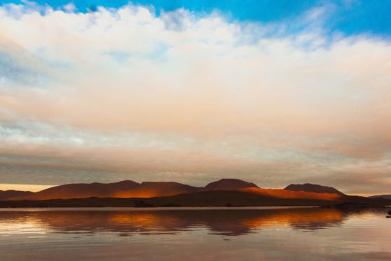
The ridge itself is a superb high-level walk. It’s well defined and at times narrow with one or two wee rocky steps, but it’s never difficult. Ahead are incredible views of Loch Tulla, the Blackmount and the hills beyond, receding into the distance in layers of shade.
The farmer at Achallader has built a large parking area at the entrance to the farm, just east of the A82. The walk in takes you past the farm buildings. They include the ruins of a great stone tower, one of the seven castles of Black Duncan of Cowal, Campbell of Glenorchy.
It was built in the 1590s to guard a cattle-droving route through to Glen Lyon. The ruins are significant as, in 1692, it was here that Robert Campbell rested with his Government troops as they made their way to Glen Coe – where they were to commit the infamous Massacre of Glen Coe.
Guide to Beinn Achaladair
Pronunciation: Ben Acha-lat-ter
Meaning: Hill of the field of hard water
Height: 3,406ft
Rank: 94
OS Landranger Map 50
Summit grid ref: NN344432
Nearest town: Tyndrum is 8.1 miles south. The small settlement at the junction of the A82 and A85 has two train stations, a pub, hotel, caravan and camping site and the famous Green Welly Stop, which sells everything from petrol to outdoor gear. For award-winning fish and chips, visit the Real Food Cafe.
The route
Start grid ref: NN313437
Distance: 13.1 miles
Ascent: 3,937ft
Time: 7hrs
Parking near entrance track to Achallader Farm. From farm, a track continues to the old bridge over the Water of Tulla, where the path forks.
Take the branch along the south bank of the river and through Crannach Wood. The path leads through ancient forest, to footbridge over rail tracks.
Follow the tracks until you meet a river – the Allt Coire an Lochain. Leave railway and follow the stream into Coire an Lochain. Head east on easy slopes to reach the ridge of Beinn a’ Chreachain.
A twisting ridge leads to the summit. Descend north-west to flatter ground which begins climbing south-west over Meall Buidhe. The route continues south-west to a col before Beinn Achaladair.
From summit, traverse over south top and continue to the bealach with Beinn an Dothaidh. Head north into corrie, back to Achallader Farm.

Enjoy the convenience of having The Sunday Post delivered as a digital ePaper straight to your smartphone, tablet or computer.
Subscribe for only £5.49 a month and enjoy all the benefits of the printed paper as a digital replica.
Subscribe