The Brocken spectre takes its name from the Brocken mountain in Germany’s Harz range, where the phenomenon was first recorded.
According to the Met Office, they are the magnified shadow of the observer, cast on to clouds or banks of mist. The sun, shining from behind the observer, throws the shadow through the mist below. Water droplets refract the sun’s rays, creating a halo of colour around the shadow, while the movement of the observer, as well as the roiling of the cloud, cause a strange sensation of movement.
The term was coined in the 18th Century by scientist Johann Silberschlag, who spent much of his time in the Harz mountains.
Some believe the spectre is the origin of the legendary Big Grey Man, said to prowl the flanks of Ben Macdui, terrifying unwary walkers.
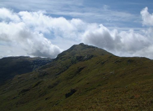
Part of a neat cluster of seven Munros just south of Crianlarich, An Caisteal is accessed easily from a large lay-by on the A82.
Toward its summit is a rocky knoll from which the hill gets its name – the castle.
An Caisteal is usually climbed with its near neighbour – Beinn a’ Chroin – the two being linked by a high col at 805m (2641ft) known as the Bealach Buidhe.
It’s the route I recommend, giving a nice short day and a pleasing round, but the hill can also be linked with others in the area.
Immediately south-west lies Beinn Chabhair – although it’s very close by, including it in the round involves a considerable height loss of more than 300m (1,000ft) and some tricky navigation in bad weather on rocky slopes.
In his excellent book, Scotland, Chris Townsend describes the traverse of all the Crianlarich Munros as one of the best high-level walks in the Highlands, if one of the least well known.
It’s a considerable undertaking, involving 3,375m (11,073ft) of ascent over 26km (16.2 miles) and at least 10 to 12 hours on the hill.
Like its neighbours, An Caisteal consists of steep, grassy lower slopes, with rocky outcrops at the summit.
In summer, the lower parts are green and lush, but it’s a steep, rugged little mountain and the small tor en route to the summit gives a wee bit of scrambling with some quite considerable exposure.
It was on this hill that I experienced an inversion for the first time – and also saw my first Brocken spectre.
I’d only climbed a handful of Munros at the time. It was an incredible feeling, breaking through the thick cloud barrier to leave a land of murk and clag for bright sun and blue skies.
The cloud beneath was like a vast, turbulent white ocean, the summits of the surrounding Munros and hills north to the Blackmount – and beyond to Glen Coe and even Ben Nevis – protruding like rocky islands.
It left quite an impression.
Guide
Pronunciation: Ann Kas-chaal
Meaning: The castle Height: 995m (3,264ft); Rank: 147
Maps: OS Landranger 50 & 56
Summit grid ref: NN378193 (cairn)
Nearest town: Crianlarich is around 5km (3.1 miles) north.
Although a small village, it has a railway station, several hotels, pubs and a youth hostel.
It also has a small corner shop, which has a limited range of outdoor kit, in case you forgot to pack something.
The route
Start grid ref: NN368238
Distance: 14.5km (9 miles)
Ascent: 1,050m (3,445ft) Time: 5hrs
Start at the lay-by on the A82. A track takes you over a bridge and along the bank of the River Falloch. After 1km (0.6 miles) head up the grassy flanks of Sron Gharbh. Ahead, the rocky knoll that gives An Caisteal its name seems to bar the way. Most fun is taking it head-on. From the summit follow the south ridge, which becomes increasingly steep and rocky, to the Bealach Buidhe. A clear path zig-zags up the rocky Beinn a’ Chroin. Some minorscrambling takes you to the plateau. East of a small lochan sits a cairn that marks the summit of this Munro at 942m (3,091ft). Backtrack slightly from, before following the north ridge and dropping into the glen. The walk out is very boggy. Follow the east bank of the River Falloch to pick up the track back to the start.

Enjoy the convenience of having The Sunday Post delivered as a digital ePaper straight to your smartphone, tablet or computer.
Subscribe for only £5.49 a month and enjoy all the benefits of the printed paper as a digital replica.
Subscribe