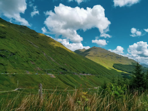
Part of the compact cluster of Munros and Corbetts known as the Arrochar Alps, Beinn Narnain is a hugely popular hill.
It’s one of the lower Munros, scraping that status by just 39ft, making it 259th in the Munro tables – but don’t be fooled into thinking it’s a lesser hill. Like its neighbours, Beinn Narnain is a very steep, rugged little mountain.
And, if following the route recommended here, the climb starts from barely above sea level, so you haul yourself up every metre.
The Arrochar Alps hold a special place in Scottish mountaineering history – the area was central to the development of climbing in the country in the 19th Century.
Partly, that’s due to the area’s proximity to Glasgow and the ease of access afforded by the West Highland Railway Line, with its station in Arrochar. But mostly it’s due to the wonderful hills themselves, in particular the Corbett Ben Arthur, better known as “the Cobbler”.
Its three summit peaks – the outer two appearing as gnarled, curving horns – provide one of the most distinctive outlines in Scotland and are visible from many miles away. They remain a lure for climbers and it’s a great venue for rock climbing.
The route suggested here gives wonderful views of the Cobbler on approach. Beinn Narnain can be linked with several of its neighbours and is commonly climbed with Beinn Ime, or indeed the Cobbler. Those seeking more of a challenge can add in the Munro Ben Vane for a three-Munro circuit, starting from Inveruglas on Loch Lomond.
As a single hill, its proximity to the A83 roadside means there’s little in the way of a walk in, which makes it a good choice for a short winter walk. Whatever your route, pick your day and you’ll be rewarded with great views down the length of Loch Long to the Kyles of Bute beyond.
Pronunciation: Ben Nar-nain
Meaning: Notched hill
Height: 3,038ft; Rank: 259
OS Landranger Map 56
Summit grid ref: NN271066 (trig point)
Nearest town: Arrochar is about 2.5 miles south-east. Heart of the Arrochar Alps, it’s a popular base for mountaineers, with a variety of accommodation, from bunkhouses, camping and a caravan park to B&Bs and hotels. There are small shops, a petrol station and places to eat and drink.
This walk starts at the Forestry Commission car park – for use of which you need to pay – just around the head of Loch Long on the north shore near Succoth.
It’s also the main car park for the trade route up the Cobbler and Beinn Ime and is normally very busy. Best to get there early. Cross the road to join a path that takes you steeply up through some woodland. Soon you’re on open hillside, where a line of concrete blocks can be followed. They’re the bases of an old rail track from the time of the construction of the nearby dam and hydro-electric scheme at Loch Sloy.
Continue north-west. The nature of the hill changes and it begins to feel much rockier and mountainous. A couple of easy scrambling sections give some fun and soon dramatic views of the Cobbler open up. The route goes over Cruach nam Miseag and soon you’re confronted by the famous Spearhead – a towering buttress of rock.
It’s easily tackled by a path to the right, up a rocky gully to the plateau. From here, the trig point lies a couple of hundred metres east.
For the return, head north-west to the Bealach a’ Mhaim. Follow the excellent path past the Narnain Boulders south-east about 3.1 miles back to the car park.

Enjoy the convenience of having The Sunday Post delivered as a digital ePaper straight to your smartphone, tablet or computer.
Subscribe for only £5.49 a month and enjoy all the benefits of the printed paper as a digital replica.
Subscribe