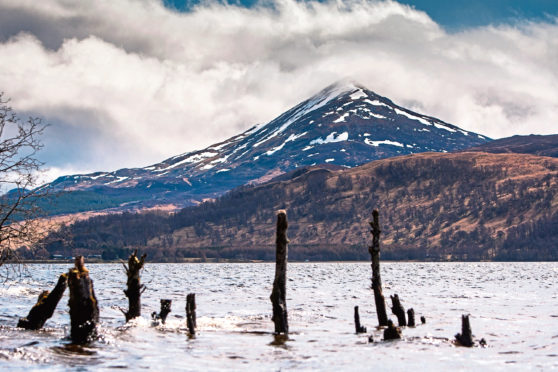
Its shape, location, name, folklore and history make Schiehallion one of Scotland’s most iconic mountains.
It’s a lonely peak, unconnected to any others. From the south, it’s a broad whaleback of a hill – but from vantage points across Loch Rannoch and the north-west, it’s conical, the perfect mountain from a child’s picture book. Schiehallion’s isolation, and unmistakable profile make it one of the easiest mountains to identify.
The mountain’s isolation and highly regular shape meant it was the ideal location for experiments in the late 18th Century to measure the mass of the Earth. It was during this work that the concept of contour lines was developed – something for which climbers and ramblers owe a debt of gratitude.
The romance of its name – Schiehallion, the fairy hill of the Caledonians – lends the hill a mystique that draws visitors to its flanks. The upper part of the mountain consists of hard white quartzite. The lower parts are limestone and contain caves – particularly on the southern slopes. There are many myths and legends associated with the mountain and its caverns. One – Uamh Tom a’ Mhor-fhir, or Cave of the Hill of the Big Man – was said to be the entrance to the land of the fairies.
With easy access,and an excellent path most of the way up, Schiehallion is a straightforward, easy Munro. The upper part, however, is a massive boulder field consisting of huge rocks – it can make going quite tough. The summit has a small cairn and the views are immense –a short distance north-east lies Beinn a’ Ghlò. Even more impressive is the view west, to the dramatic Glen Coe, rising sharply beyond the flat, watery expanse of Rannoch Moor.
Pronunciation: Shee-hally-yan
Meaning: Fairy hill of the Caledonians
Height: 1083m (3553ft); Rank: 59
OS Landranger Map 51
Summit grid ref: NN713547 (small cairn)
Nearest town: Aberfeldy is the nearest town of any size, about 21km (13.miles) east of the summit. It’s a market town and has all the amenities you’d expect. It’s also the home of Dewar’s whisky and the local bookshop, the Watermill, was named one of the best in the world by New Yorker magazine.
Start grid ref: NN753556 Distance: 10km (6 miles) Ascent: 760m (2,493ft)
Time: 4hrs
The route I’d recommend is from the Braes of Foss car park on the path constructed by the John Muir Trust a few years ago.
The path, which follows an older line up the hill, heads up Schiehallion’s long east ridge. It’s not waymarked, but is simple to follow.
The superb track makes going easy and the ascent is quick, the views improving as height is gained. The track ends at a large cairn at the start of the enormous summit boulder field.
The walking becomes very rough, the route twisting among massive quartzite rocks and boulders – care should be taken, and this stony section seems to go on much longer than you first expect.
If you’re a winter walker, with the appropriate equipment and experience, this is a great choice for a short day. Simply reverse the route to return to the car park, on the JMT path.
Some walkers don’t like such prescribed, maintained routes, the feeling being perhaps that constructed paths make access too easy and detract from the “wildness” of an area. While that’s a view with which I have some sympathy on a hill as popular as this, it’s just not practical.
The damage and erosion caused by many thousands of feet is clear to see on too many of our hills.
For 17 rain-soaked weeks through the summer of 1774, Astronomer Royal, Nevil Maskelyne, lived in a bothy on Schiehallion as he attempted to calculate the mountain’s mass, and thus determine the density of the Earth.
The experiment involved carefully measuring the mountain to work out what proportion of the Earth it represented – this could be done as the circumference of the planet was already known.
Schiehallion was selected as its regular shape meant it was relatively easy to measure. Charles Hutton was the man charged with finding the mountain’s volume. He worked out it was easier to first measure regularly shaped “slices” of the mountain, and add their volumes together.
These slices became the contour lines familiar to walkers today. The mass of the mountain was worked out using pendulums, as the gravitational pull of the hill tugged a plumb weight slightly out of true. Using this angle to calculate the mass of the hill, it was then a case of extrapolating the figure to give the density of the Earth.
The figures were pretty accurate, 4,500kgm-3.
Today it is recorded as 5,515kgm-3.

Enjoy the convenience of having The Sunday Post delivered as a digital ePaper straight to your smartphone, tablet or computer.
Subscribe for only £5.49 a month and enjoy all the benefits of the printed paper as a digital replica.
Subscribe